


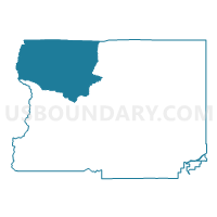
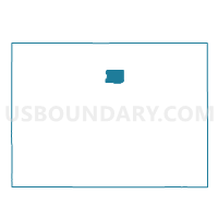
Boulder 2, Boulder County, Colorado
About
Outline

Summary
| Unique Area Identifier | 546818 |
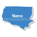
| Name | Boulder 2 |
| County | Boulder County |
| State | Colorado |
| Area (square miles) | 113.66 |
| Land Area (square miles) | 113.18 |
| Water Area (square miles) | 0.49 |
| % of Land Area | 99.57 |
| % of Water Area | 0.43 |
| Latitude of the Internal Point | 40.19725080 |
| Longtitude of the Internal Point | -105.53274530 |
Maps

Graphs
Select a template below for downloading or customizing gragh for Boulder 2, Boulder County, Colorado


Neighbors
Neighoring Voting District (by Name) Neighboring Voting District on the Map
- Boulder 3, Boulder County, CO
- Boulder 7, Boulder County, CO
- Boulder 9, Boulder County, CO
- Grand 1, Grand County, CO
- Grand 3, Grand County, CO
- Larimer 413, Larimer County, CO
- Larimer 416, Larimer County, CO
Top 10 Neighboring County Subdivision (by Population) Neighboring County Subdivision on the Map
- Bald Mountain CCD, Boulder County, CO (12,286)
- Granby CCD, Grand County, CO (11,932)
- Estes Park CCD, Larimer County, CO (11,309)
- Upper St. Vrain CCD, Boulder County, CO (912)
Top 10 Neighboring Place (by Population) Neighboring Place on the Map
Top 10 Neighboring Unified School District (by Population) Neighboring Unified School District on the Map
- Boulder Valley School District RE-2, CO (212,161)
- St. Vrain Valley School District RE 1J, CO (151,981)
- East Grand School District 2, CO (11,977)
- Park School District R-3, CO (11,493)
Top 10 Neighboring State Legislative District Lower Chamber (by Population) Neighboring State Legislative District Lower Chamber on the Map
- State House District 49, CO (83,740)
- State House District 57, CO (78,537)
- State House District 13, CO (69,892)
Top 10 Neighboring State Legislative District Upper Chamber (by Population) Neighboring State Legislative District Upper Chamber on the Map
Top 10 Neighboring 111th Congressional District (by Population) Neighboring 111th Congressional District on the Map
Top 10 Neighboring Census Tract (by Population) Neighboring Census Tract on the Map
- Census Tract 137.01, Boulder County, CO (6,334)
- Census Tract 28.02, Larimer County, CO (5,861)
- Census Tract 2.01, Grand County, CO (4,817)
- Census Tract 19.03, Larimer County, CO (3,765)
- Census Tract 136.02, Boulder County, CO (912)
- Census Tract 28.03, Larimer County, CO (92)
Top 10 Neighboring 5-Digit ZIP Code Tabulation Area (by Population) Neighboring 5-Digit ZIP Code Tabulation Area on the Map
- 80517, CO (9,313)
- 80540, CO (4,461)
- 80447, CO (1,964)
- 80481, CO (572)
- 80455, CO (497)
- 80510, CO (420)